Public Data Endpoints
Overview
Teaching: 10 min
Exercises: 0 minQuestions
What public endpoints does OTN provide, and when should I use each?
Objectives
Identify the Discovery Portal, GeoServer, OBIS, and ERDDAP.
Understand the purpose of each endpoint.
Select the right endpoint for mapping, biodiversity records, or tabular analysis.
The Big Picture
The Ocean Tracking Network (OTN) makes much of its data publicly available. There isn’t just one access point — instead, OTN provides several endpoints, each designed for a different type of use.
- Discovery Portal → the searchable catalogue of OTN datasets.
- GeoServer → spatial data services for maps and GIS (stations, receivers, moorings).
- OBIS → biodiversity/occurrence datasets (species records).
- ERDDAP → analysis-ready tabular datasets with filtering and download options.
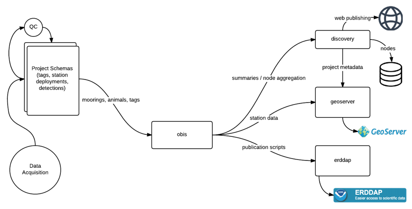
Public Endpoints
-
Discovery Portal (catalogue): https://members.oceantrack.org/data/discovery/bypublic.htm
- Human-friendly entry point.
- Provides search and links to datasets across OTN systems.
-
GeoServer (spatial layers): http://geoserver.oceantrack.org/geoserver/web/?1
- Serves GIS-ready data via WFS/WMS (e.g., CSV, GeoJSON).
- Best for mapping stations, receivers, and moorings.
- Example: integrating OTN station layers in QGIS.
- → See: GeoServer episode.
-
OBIS (biodiversity occurrences): https://obis.org/node/68f83ea7-69a7-44fd-be77-3c3afd6f3cf8
- Global standard for species occurrence data.
- OTN contributes datasets with UUID identifiers.
- Ideal for querying animal presence/absence or species distribution.
- → See: OBIS episode.
-
ERDDAP (tabular/time-series): https://erddap.oceantrack.org/erddap/index.html
- Provides time-series and detection datasets in formats like CSV, JSON, NetCDF.
- Supports subsetting and reproducible queries.
- Suitable for analysis pipelines and scripting.
- → See: ERDDAP episode.
Which Endpoint Should I Use?
- Need spatial layers or GIS integration? → GeoServer
- Need species occurrence data for biodiversity studies? → OBIS
- Need tabular or time-series data for analysis? → ERDDAP
- Not sure where to start? → Discovery Portal
Private Data (OTN Collaborators)
For OTN-affiliated projects, additional Detection Extracts are available in secure project repositories under Detection Extracts. See documentation: https://members.oceantrack.org/OTN/data/otn-detection-extract-documentation-matched-to-animals
Key Points
Discovery Portal = searchable catalogue
GeoServer = spatial layers (WFS/WMS)
OBIS = biodiversity occurrence datasets (UUID-based)
ERDDAP = analysis-ready tables with filtering